激光SLAM之NDT算法(2)-建图
最近的项目里用到了室外激光SLAM进行定位,所以我总结一下项目经验,顺便根据项目最终效果说一下自己对于算法源码中这段代码的理解。
首先,算法框架中用到了不止一种传感器,包括IMU,odometry和GPS等。所有的传感器数据都是为了能构造一个合理且较好的激光里程计。
这段代码很好理解,我大致讲一下流程吧,首先当第一帧点云输入时,我们构造一个位姿向量,x=0,y=0,z=0,旋转角初始化为0,存入map)中,并将其设置为ndt的target参数。当第二针点云进来时,进行点云匹配得到这堆点云的位姿(以lidar为坐标系),由于设置有shift值来判断这帧点云是否距上一帧点云位移了1m,所以我们会根据得到的位姿进行计算,如果小于1m,丢弃,用下一帧点云重复这个过程,如果大于1m,则存入map,并重置它为ndt的target参数,以此类推 ,对下一帧点云重复这个动作。代码如下:
void ndt_mapping::points_callback(const sensor_msgs::PointCloud2::ConstPtr& input)
{
  pcl::PointCloud<pcl::PointXYZI> tmp, scan;
  pcl::PointCloud<pcl::PointXYZI>::Ptr filtered_scan_ptr(new pcl::PointCloud<pcl::PointXYZI>());
  pcl::PointCloud<pcl::PointXYZI>::Ptr transformed_scan_ptr(new pcl::PointCloud<pcl::PointXYZI>());
  tf::Quaternion q;

  Eigen::Matrix4f t_localizer(Eigen::Matrix4f::Identity());
  Eigen::Matrix4f t_base_link(Eigen::Matrix4f::Identity());
  //static tf::TransformBroadcaster br;
  tf::Transform transform;

  pcl::fromROSMsg(*input, tmp);
  double r;
  Eigen::Vector3d point_pos;
  pcl::PointXYZI p;
  for (pcl::PointCloud<pcl::PointXYZI>::const_iterator item = tmp.begin(); item != tmp.end(); item++)
  {
    if(use_imu_){
      // deskew(TODO:inplement of predicting pose by imu)
      point_pos.x() = (double)item->x;
      point_pos.y() = (double)item->y;
      point_pos.z() = (double)item->z;
      double s = scan_rate_ * (double(item->intensity) - int(item->intensity));

      point_pos.x() -= s * current_pose_msg_.pose.position.x;//current_pose_imu_
      point_pos.y() -= s * current_pose_msg_.pose.position.y;
      point_pos.z() -= s * current_pose_msg_.pose.position.z;

      Eigen::Quaterniond start_quat, end_quat, mid_quat;
      mid_quat.setIdentity();
      end_quat = Eigen::Quaterniond(
        current_pose_msg_.pose.orientation.w,
        current_pose_msg_.pose.orientation.x,
        current_pose_msg_.pose.orientation.y,
        current_pose_msg_.pose.orientation.z);
      start_quat = mid_quat.slerp(s, end_quat);

      point_pos = start_quat.conjugate() * start_quat * point_pos;

      point_pos.x() += current_pose_msg_.pose.position.x;
      point_pos.y() += current_pose_msg_.pose.position.y;
      point_pos.z() += current_pose_msg_.pose.position.z;

      p.x = point_pos.x();
      p.y = point_pos.y();
      p.z = point_pos.z();
    }
    else{
      p.x = (double)item->x;
      p.y = (double)item->y;
      p.z = (double)item->z;
    }
    p.intensity = (double)item->intensity;

    // minmax
    r = sqrt(pow(p.x, 2.0) + pow(p.y, 2.0));
    if (min_scan_range_ < r && r < max_scan_range_)
    {
      scan.push_back(p);
    }
  }

  pcl::PointCloud<pcl::PointXYZI>::Ptr scan_ptr(new pcl::PointCloud<pcl::PointXYZI>(scan));

  // Add initial point cloud to velodyne_map
  if (initial_scan_loaded == 0)
  {
    pcl::transformPointCloud(*scan_ptr, *transformed_scan_ptr, tf_btol_);
    map_ += *transformed_scan_ptr;
    initial_scan_loaded = 1;
  }

  voxel_grid_filter_.setInputCloud(scan_ptr);
  voxel_grid_filter_.filter(*filtered_scan_ptr);
  ndt.setInputSource(filtered_scan_ptr);//设置配准的点云

  pcl::PointCloud<pcl::PointXYZI>::Ptr map_ptr(new pcl::PointCloud<pcl::PointXYZI>(map_));
  if (is_first_map_ == true){
    ndt.setInputTarget(map_ptr);//设置点云配准目标
    is_first_map_ = false;
  }

  Eigen::Translation3f init_translation(current_pose_.x, current_pose_.y, current_pose_.z);
  Eigen::AngleAxisf init_rotation_x(current_pose_.roll, Eigen::Vector3f::UnitX());
  Eigen::AngleAxisf init_rotation_y(current_pose_.pitch, Eigen::Vector3f::UnitY());
  Eigen::AngleAxisf init_rotation_z(current_pose_.yaw, Eigen::Vector3f::UnitZ());

  Eigen::Matrix4f init_guess =
      (init_translation * init_rotation_z * init_rotation_y * init_rotation_x).matrix() * tf_btol_;

  pcl::PointCloud<pcl::PointXYZI>::Ptr output_cloud(new pcl::PointCloud<pcl::PointXYZI>);

  ndt.align(*output_cloud, init_guess);
  t_localizer = ndt.getFinalTransformation();

  t_base_link = t_localizer * tf_ltob_;

  pcl::transformPointCloud(*scan_ptr, *transformed_scan_ptr, t_localizer);

  tf::Matrix3x3 mat_b;
  mat_b.setValue(static_cast<double>(t_base_link(0, 0)), static_cast<double>(t_base_link(0, 1)),
                 static_cast<double>(t_base_link(0, 2)), static_cast<double>(t_base_link(1, 0)),
                 static_cast<double>(t_base_link(1, 1)), static_cast<double>(t_base_link(1, 2)),
                 static_cast<double>(t_base_link(2, 0)), static_cast<double>(t_base_link(2, 1)),
                 static_cast<double>(t_base_link(2, 2)));

  // Update current_pose_.
  current_pose_.x = t_base_link(0, 3);current_pose_.y = t_base_link(1, 3);current_pose_.z = t_base_link(2, 3);
  mat_b.getRPY(current_pose_.roll, current_pose_.pitch, current_pose_.yaw, 1);//mat2rpy

  transform.setOrigin(tf::Vector3(current_pose_.x, current_pose_.y, current_pose_.z));
  q.setRPY(current_pose_.roll, current_pose_.pitch, current_pose_.yaw); //q from rpy
  transform.setRotation(q);//trans from q

  br_.sendTransform(tf::StampedTransform(transform, input->header.stamp, "map", "base_link"));

  double shift = sqrt(pow(current_pose_.x - previous_pose_.x, 2.0) + pow(current_pose_.y - previous_pose_.y, 2.0));
  if (shift >= min_add_scan_shift_)
  {
    map_ += *transformed_scan_ptr;
    previous_pose_.x = current_pose_.x;previous_pose_.y = current_pose_.y;previous_pose_.z = current_pose_.z;
    previous_pose_.roll = current_pose_.roll;previous_pose_.pitch = current_pose_.pitch;previous_pose_.yaw = current_pose_.yaw;
    ndt.setInputTarget(map_ptr);

    sensor_msgs::PointCloud2::Ptr map_msg_ptr(new sensor_msgs::PointCloud2);
    pcl::toROSMsg(*map_ptr, *map_msg_ptr);
    ndt_map_pub_.publish(*map_msg_ptr);
  }
  current_pose_msg_.header.frame_id = "map";
  current_pose_msg_.header.stamp = input->header.stamp;
  current_pose_msg_.pose.position.x = current_pose_.x;current_pose_msg_.pose.position.y = current_pose_.y;current_pose_msg_.pose.position.z = current_pose_.z;
  current_pose_msg_.pose.orientation.x = q.x();current_pose_msg_.pose.orientation.y = q.y();current_pose_msg_.pose.orientation.z = q.z();current_pose_msg_.pose.orientation.w = q.w();

  current_pose_pub_.publish(current_pose_msg_);
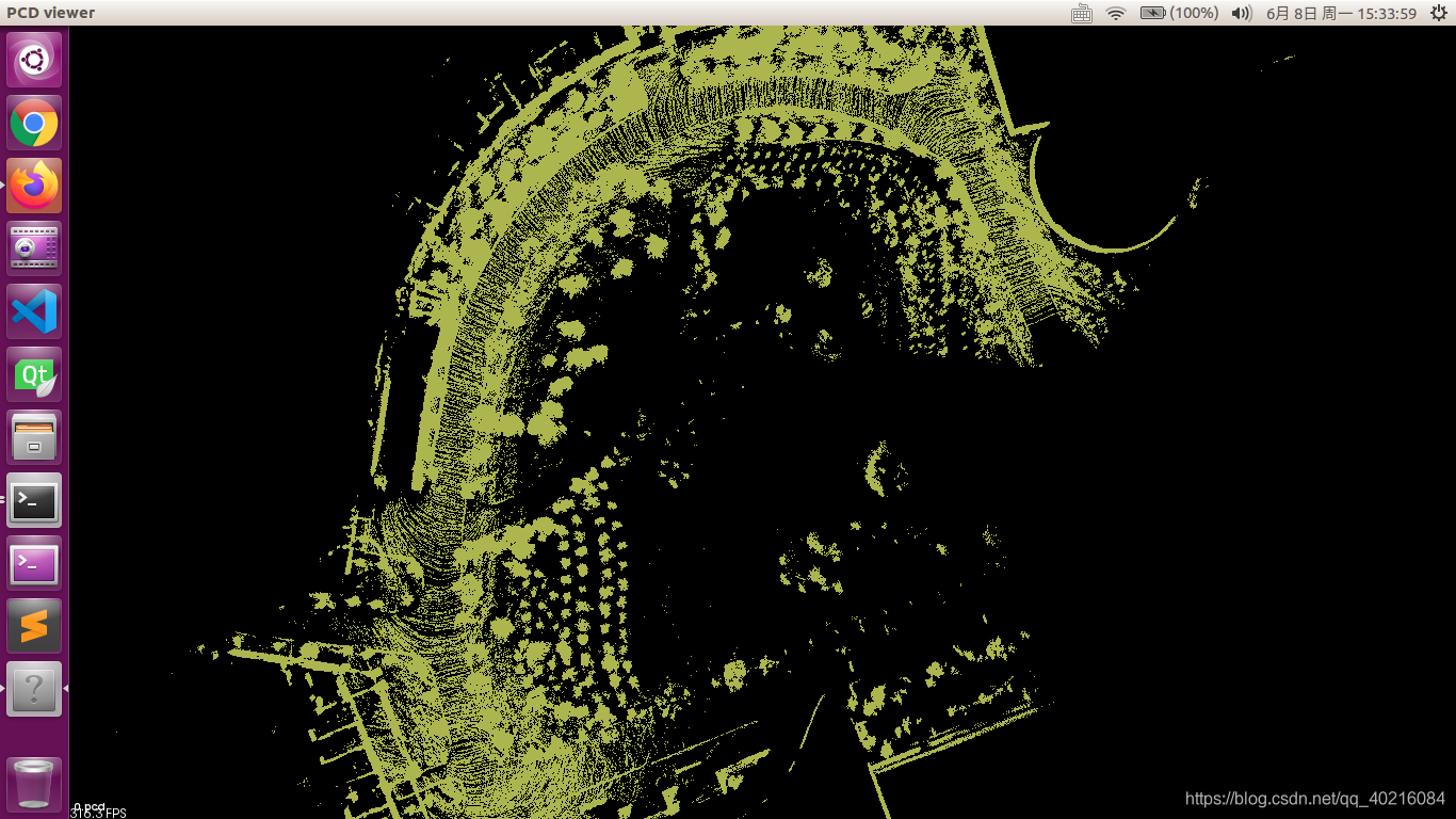
那么,效果如何呢?
 这么来看地图构建的还不错,而且场地也很大,但是呢,这个图我并为构建完成,因为在后面的时候,出现了漂移,这个也是可以预期的,毕竟我只用了激光雷达,而且系统中并未有后端设计和回环检测,所以,地图飘是可以预见的
这段代码可以看出,这中构建激光里程计 方法其实更像是点云拼接。
如果不考虑回环检测和后端优化,我们大可通过加入其他传感器来减小累计误差,注意,我说的是减小,它本身的误差已经很大了,只是相对于只用激光雷达来说,能让有个大致的样子。
另外不得不说的是速度问题,由于我用的是pcl_ndt的,所以速度极慢。建图的准确度对与匹配定位来说,是有一定影响的,所以关于建图这一块,我个人的话,还是需要研究的,如果有新的进度会跟大家分享的,暂时这篇先到这里。